
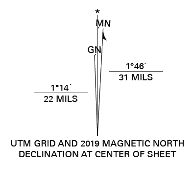
UTM Grid vs. Magnetic North
The 2023 Simulated Emergency Test will require the determination of a magnetic angle from the location of a radio direction finder to a transmitted radio signal. Then, the observation must be plotted on a grid-based map as part of an area-of-interest polygon.
Since Magnetic North (MN) is not always the same as Grid North (GN), there is a delta that must be accounted for: The Grid Magnetic (GM) angle.
Good news! Here in eastern Kansas, the angle is rather small; around than 3 degrees. For accurate plots, the angle must be accounted for. The angle difference in Leavenworth is:
Magnetic Bearing to Map (Grid): Grid = Magnetic Bearing + 2.7°
Map (Grid) to Magnetic Bearing: Magnetic Bearing = Grid – 2.7°
The third line in the diagram is marked by a star. This is True North and is calculated from the rotation of the earth around its axis as observed astronomically. Since we are not laying the foundation for pyramids, we will not need to calculate this angle.
To determine the GM angle for your specific location, use Map Tools — Declination Reference Sheet Design or similar calculator.
- Declination Reference Sheet for Leavenworth, KS
- Declination Reference Sheet for Easton, KS
- Declination Reference Sheet for Winchester, KS
Remember, your magnetic compass may be affected by metal objects, magnetic anomalies in the earth, and time. The magnetic poles move and the earth is subject to geomagnetic storms.